Kia Ora!
Greetings again from Aotearoa with my latest blog post. Last time I left you I had returned to Rotorua after spending a period of time staying on the East Cape where in my opinion I found the 'real, raw New Zealand' living in the Maori community of Tokomaru Bay.
But here's a good evening message from the heart of the North Island of New Zealand..at the great Lake Taupo.
Prior to arriving in Taupo or 'Taupo-Nui-a-Tia' (The great cloak of Tia) I travelled down Highway 5 on the Stray bus 65 kms southeast of Rotorua through the Kaingaroa Forest which is the largest hand planted forest in the Southern Hemisphere. During the 1930's, the NZ government hired cheap labour (available because of the Depression) to plant Radiata Pines (a Californian native tree) and are 20 - 25 years old. Between 12,000 - 15,000 trees are planted per hectare and blocks of 80,000 hectares are felled at one time and used for timber, paper, and pulp. Today there is still campaigning from the Maoris for ownership and rights to plant their own trees on this land.
On route at Rainbow Mountain, we were taken through the forest by a native Maori man of the Ngati Manawa tribe to the site of some very sacred Maori rock art and told us how the Maori used the underside of the silver fern leaves to use as light under the moon - but would turn them over when they were being chased in battle to disguise the light of their path ....clever hey...

The rock art was likely to been carved in 1050 AD by members of the Te Manawa Tribe (Manawa meaning 'heart' which the chief of this tribe took the heart of an opposing chief and put it on a stick to secure its tribal boundaries. Maori's usually devoured their fallen enemies and believed if they possessed or ate different organs of their body, it gave them their skills eg. The heart meaning he would possess the soul and courage of the warrior, the eyes - he would be able to gain the strategist and see the things others didn't in battle, and the brain - gain the wisdom and knowledge from the wise warrior.


Lake Aniwhenua


Lake Aniwhenua

Resident pets....Ozzie the Ostrich, Bambi the Deer and Charlie Brown the friendly goat....

For our communal meal we were being treated with the traditional ground cooked hangi feast with the water rocks here being blow torched to 600 - 700 degrees Celsius - now that is flaming hot!. Specific rocks are needed to be collected for a hangi, you can't just use ones collected from the garden path as they'll just explode! The ones used in a hangi are collected from the rivers and contain quartz like crystals which glow in the moonlight in the water - cool!


When the rocks are at the right temperature, the layers of food pods are stacked, meat always going at the bottom as they need to be cooked the most and then veggies and stuffing on top. In Maori culture, men are expected to carry out the responsibility of dressing the hangi whilst the woman stood back and barked orders haha!

The food is then dressed with wet sac cloths which causes all the steam and then a tarpaulin sheet placed over the top covered in sand to make a real underground pressure cooker that keeps all that heat in and makes all the juices drip onto the food. The cleaver thing about cooking in this method is that instead of having to do the meat and vegetables separate like you would in an oven for different time periods - the way the steam and smoke circulate underneath the mound causes the food to never become overcooked and can all be cooked for the same time period - so clever the Maori!

The hangi is left for 3 hours to roast.....
As this was a very unique cultural stop on the Stray, it gave us an opportunity to connect us spiritually with the Te Manawa people and their home and strive to make a positive difference in their area by teaching visitors traditional Maori crafts and activities....like flax weaving, where Aunty Marge here taught us how to make a bracelet using two strips of a flax plant and a clothes peg.


Hey, hey not bad! Kar pai!
For those of us who wanted to learn, Aunty Marge was happy to teach us how to make fried bread, which we were going to have with the hangi. She taught us from scratch and gave us each a small task in preparing the bread - four cups of yeast, four cups of sugar, fourteen cups of flour, four cups of milk.....


Stirring the yeast slighty and then left to rise for 20 minutes or so...


Mixed together and then kneeded into a thick pizza style base and then cut into pieces to pop into the fryer.


And moments later, the bread plumps up and ready to coat with cream and syrup...

After our epic Hangi, our Maori host Karl offered to take us out 'eeling' after dark out on Lake Aniwhenau. Eels are very significant in the Maori make up of the Te Manawa people and eels are a plenty in the lake and have a fascinating breeding process - departing every year on their journey from the rivers to the ocean for spawning. Our hosts were campaigning passionately about getting the dam that are peppered down the river to have eel holes so that they can get themselves to the ocean. At present, they are having to physically take them out to sea and collect the elvers who can't swim and bring them back to the river to grow as a food resource.
So......kitted up with funky waders, we ventured out into the night onto the lake with bait and fishing lines to go back to our hunter gatherer ways ...


Bait, check.

Out on the lake, we wait patiently into the night for that anticipated tug on our lines....

Hunter gathering being very much the male responsibility in the Maori world, I of course remained humble when I was the first to catch an eel from the lake to provide the next set of guests at the lodge with some food ha!

Then more eventually followed...and we didn't have to return to the tribe empty handed....

Murupara Maori School
 Now being on the Stray Backpacker bus didn't just mean having our own adventures on our travels across New Zealand - we could make a difference too from our footprint as part of our stay at Lake Aniwhenua. Our lovely Maori hosts Nadine and Karl strived for their business to help the poverty stricken small township of Murupara, a rustic and serene corner of Aotearoa. The town does not have the most fruitful reputation in the Bay of Plenty with high crime, unemployment and a pessimistic outlook for a future. The ones who feel the affect of this the most are the Maori children of Murupara town so we were given the opportunity after breakfast to visit the new local school to personally deliver individual pre-packed hangi meals, leftovers from our own hangi, to the children - some of which go without breakfast and lunch everyday.....
Little did we know we would get an unexpected welcome with their very own haka!


The young Maori girls, show us their performance of the poi

We were given the chance to sit down with the 6 - 9 year old children and draw pictures with them and ask them about themselves and tell them about England - one of the young boys really took to my camera and wanted to learn everything about it so I have him to thank for these photos! Many of the children are very bright and aspire to become successful adults with dreams of becoming pilots, soccer stars, joining the navy....maybe even a photographer!


Kia Ora!
The idea of visiting the school was to make a difference through 'real tourism' and get a taste of the reality that exists today for Maori children in New Zealand - very much a unique experience spending an hour with these little guys who we hope enjoy their hangi lunches!

Huka Falls just on the fringe of Taupo, is New Zealands most visited natural attraction on the Waikato River and at 11m high the volume of water it produces is every three seconds enough water flows through the falls to fill an Olympic sized swimming pool! Look at that water though - spectacular!

Welcome to Lake Taupo!
I made it to the centre of the North Island, the 'eye' of the fish of Maui which is the great Lake Taupo or 'Toe-paw' as pronounced by the Maori. Formed in 181AD into a volcanic crater, the eruption created such a mess that its effects on the weather and sky were recorded in ancient Rome and China, making the area still volcanically active with geo-thermal activity. The largest lake in New Zealand and the Southern Hemisphere, it is named after the Polynesian chief 'Tia' who came and slept beside the shore from Tahiti in the canoe Arawa who believed one of the cliffs resembled the flax cloak he was wearing. Lake Taupo's water is the main source for the towns consumption and can drop by 2 metres a year.
Another Maori chief 'Ngatoro-i-rangi' proclaimed the lake would be 'drinking water for my grandchildren' tearing off a feather from his cloak and casting it out on the waters of the lake - touching the waters, it turned into an eel which did not survive and again he cast a new feather which turned into a 'Koaro' white bait fish making it the traditional fishing breed of Lake Taupo. The name of Taupo is also believed to be derived from this same ancestor when he and his tribe decided to settle at the lake for a rest before journeying to the base of Tongariro - 'Tau' (settle) and 'po' (night)
Don't you just love Maori stories hey?

Stunning, the most beautiful lake in New Zealand!


The Maori Wall Carvings of Lake Taupo

On a beautiful autumn morning, launching out of Acacia Bay on the north of the Lake, we began paddling towards our destination an hour away near Mine Bay in our very own wakas in search of the carvings...


Passing by sheltered rock lots where the Maori would moor their canoes, steering them in between the rocks to keep them hidden and sheltered from the elements of the lake - clever hey!

And round the cliff at Mine Bay.....the 10 metre wall comes into sight with the huge Maori Face Carving designed by carver Matahi Whakataka-Brightwell.
As ancient as it may look, the carvings are only 40 years old! carved in the late 1970's by three Maori Carvers, Head Carver Whakataka-Brightwell was asked to do a carving on a felled log at his Marae in Taupo by his grandmother, but when he travelled up to Taupo, he discovered that his cousins had been tardy in felling the log for him, so wanting to please his grandmother - he found the cliff face at Mine Bay, smoothing it out for he and his carver colleagues to set to work in making a masterpiece for the people of toe - paw!

Magnificient! and I was only able to get this close to the 10 metre carving in my canoe. The carving took three summers to complete and was necessary for scaffolding to be erected in the waters of the lake to enable the carvers to chisel away with stone and hammers (can imagine it was pretty wobbly too!). Some believe the face depicts Ngatoto-i-rangi, the visionary Maori chief navigator who named the lake and guided the Tuwharetoa and Te Arawa tribes to Taupo a thousand years ago and acts as Guardian of the lake.
But....local knowledge tells me that the face is in fact a cryptic amalgamation of each member of his interwoven family of married-into tribes, with each curve and line representing each member of that extended family - cool!
You notice there are two mouths on the face? well, originally the carvers were doing one mouth, but Maori carvings on rock as opposed to wood was highly criticised by the community and gave the carvers such a hard time about their project that they sealed the mouth in the middle as a statement to shut out their negative energy!


More Maori Rock Carvings on the face of the cliffs depicting women and birds

Pulling up onto Mine Bay for a rest and a lovely view of the Lake


Heading back to Acacia Bay, we spot Mt. Tauhara which has its own Maori legend...

Very cool - a cultural highlight of my travels in Aotearoa
Tongariro Alpine Crossing

The challenge that awaits...
You see the distant peaks of those volcanoes in the background? those are the summits of Mt. Tongariro, Mt. Ruapehu and Mt. Ngauruhoe AKA 'Mt. Doom' on the famous Tongariro Alpine Crossing south of Lake Taupo and is NZ most famous Day Walk covering 19km across a volcanic plateau, hot springs, boiling mud pools, colourful lakes, steaming craters and glacial valleys. Its not a light decision to undertake the trek because of its remoteness, length and height above the sea level which can cause the weather to change quickly.
And I signed up to do it.

The Tongariro National Park is NZ first National Park and was created in 1887 when a chief of the Ngati Tuwharetoa tribe gifted the three volcanoes to the people of New Zealand...and the tourists.... - thanks!
To do the walk itself is free, but you pay for transport there and back from Taupo and coming into NZ winter its a 5.30am pick up to the National Park and you begin the walk at 7am as the sun is rising. You have 9 1/2 hours to make the 19/4 km across the crossing and to the other side of the National Park and given a trusty map with check in times and emergency contacts one of which is 'Bugger I missed the bus!' haha! at least they have a sense of humour about it all! In the thick of winter, with the snow fall, you need to have a guide and snow equipment to
To share this with you, I recorded some of what was to be one of the most hardest things I've done.

Sunrise and the start of the Tongariro Alpine Crossing....what was to come....the challenge is on


Mangatepopo Stream to Soda Springs


First stop and toilet stop for the next 3 1/2 hours....Soda Springs!
Soda Springs to South Crater (The Devils Staircase)
Ok, so this part of the crossing was the first of the tough times that was to come on the journey, scaling to the South Crater at 1660 metres high was known as a the 'Devils Staircase' which was pretty much a strenuous staircase ascending to the South Crater and base of Mt. Ngaruhoe (Mt. Doom). They certainly get the names right on these things!


Finally at the South Crater - 1660 metres up!
Mt. Ngauruhoe - The peril of Mt. Doom

Now this sounds like something from an Indiana Jones adventure but here we were at the base of Mt. Ngauruhoe which is the youngest of the three volcanoes at Tongariro erupting 2500 years ago - it is also known as Mount Doom from its appearance in the Lord of The Rings movies.

Ain't no mountain high enough!
At 2291 metres above sea level - we were pre-warned that this track was extremely dangerous and should only be attempted if we found the Devil's Staircase easy....... so, along with other sorry souls we decided to pass some time and give it a crack up to the summit....thinking it was such a great idea - is it humanly possibly to scale such a volcano like this?
Yep and here's a slight idea of what it was like taking on 'The Doom'

It first started off as a reasonably straight forward climb up the rocks to the slopes and that's when the loose igneous rocks and soft gravel became a struggle....but there was no turning back.....you just have to keep going....breathing and taking one step at a time...all you have is mental strength and taking it in your stride....


Holy moly...who's great idea was this???


After 1 1/2 hours we finally arrived at the summit of Mt. Doom and it was the best feeling in the world and heavily relieving! I was kinda disappointed there was no T-Shirt stand at the top for us to get a souvenir for our efforts - still high fivin' and massive congratulations to everyone who endeavored to reach the highest point at Tongariro.

On top of the world!


The crater of Mt. Doom and the view of New Zealand

But what goes up. must come down and we certainly weren't prepared for this dangerous descent down the loose and unstable scree with steaming hots spots on the volcanic region, you can feel them with your hands and the rocks moving underneath you...

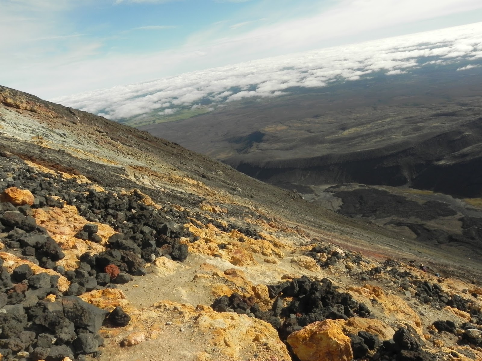


I think the look on my face says it all as I show you a slight taste of what its like to slide down the side of a volcano, falling rocks and all.....one of the most dangerous things I've done.
But, of course I made it down 1 1/2 hours later, with lots of dusty, torn leggings, a ton of stones in both my boots and all those things that are part and parcel with taking on a volcano!
South Crater to base of Red Crater Ridge
We were advised, this was the POINT OF NO RETURN, sounds scary doesn't it? but it meant if you were having difficulty or the weather had closed in and was looking sketchy, we should turn back - of course I wasn't turning back now and nothing could have been more difficult than going up and down that colossal beast that was Doom...even though I was exhausted......but pushing past the point of no return, I was determined to complete the crossing and make it to the end.


Reaching the Red Crater Ridge was the steepest part of the crossing (steep.....that cone thing behind it there was steep) so I had no qualms with pushing on along the crater ridge with its brilliant colourful volcanic features. The crater is still active and there's natural underground heating if you're looking for a hot spot to sit on. On a clear day, you can see coast - to - coast across New Zealand.


The Red Crater edge at 1886 metres


Red Crater Summit to Emerald Lakes
This route was a little unstable down to the Emerald Lakes with the strong winds so you needed to take great care (and yes, I did tumble a few times) but after sliding down a volcano, I was over it and arrived at the stunning tinted lakes with a spectacular backdrop of Tongariro Mountain and valleys now being inside the Central Crater of Tongariro.


Battling through the strong winds...I introduce you to the Emerald Lakes..

The Emerald Lakes of Tongariro - no swimming allowed unfortunately
Emerald Lakes to Ketetahi Shelter
Having ascended to the highest point on the Tongariro Alpine Crossing, the rest of the journey was going to be easier as I descended down the North face following the Rotopaunga Valley passing steaming craters towards the Ketetahi Shelter 1 1/2 hours later.


Into the mist we go, hopefully not to disappear...following the winding road down the mountain side


Final stop on the crossing, the Ketetahi Shelter before the home straight!

Ketetahi Shelter to The Crossing Finish
This was it! I had made it to the final check point and knew I was going to complete the Alpine Crossing in time, I didn't want to hang around long in case I started stiffening up which would make the final couple of hours more difficult so I pushed on down the home straight taking in the late afternoon sunshine and final views of the smoldering mountains and glacial lakes.


I finish and make the final bus back to Taupo - wahooh!

So, my adventure is over and I survived the Tongariro Alpine Crossing (sounds dead cool doesn't it?) In a total of 9 1/2 hours of my life, I had covered 22km of steaming crater ridges, emerald lakes, glacial valleys, deserts and lush New Zealand forest - not to mention conquering the biggest mountain in the National Park and lived to tell the tale. As challenging and sometimes arduously painful, mental strength and determination can get you through these challenges and having been one of the most difficult things to accomplish, these things make you stronger.......and never been so excited to have a shower!
That's all from my latest mishaps of here in Aotearoa - will write again of any exciting things I encounter as I continue my journey south down the North Island on my way to New Zealand's great capital, Wellington.


Finding myself being a model for Taiwanese photographers - sweet!
Kia Ora and signing off till next time.

Taupo, New Zealand
Taupo, New Zealand

With Lonely Planet Travel Guide New Zealand
No comments:
Post a Comment
Scribble back!